

Volgograd scientists are conducting long-term monitoring of farmland in arid areas of the European part of Russia to identify the degree and dynamics of desertification
Amid changing climate, irrational use, and increased anthropogenic load, active degradation processes occur on arid lands, which sometimes lead to irreversible changes in ecosystems – to the loss of natural bioproductivity of the soil and its gradual desiccation, loss of vegetation diversity. Regular monitoring by experts helps to identify problematic areas of desertification promptly, and then develop and implement measures for the conservation and restoration of arid zones.
Specialists of the Federal Research Service for Agroecology of the Russian Academy of Sciences (Volgograd) are engaged in the analysis of digital spatial data to find out the formation and current state (soil, thermodynamic, geomorphological characteristics) of agricultural plots subject to change because of climatic and anthropogenic influence. The practice of using geoinformation and remote cartographic assessment, the unique method of forecasting desertification helps to accurately determine the level, dynamics, and patterns of land degradation in arid ecosystems to take effective environmental measures.
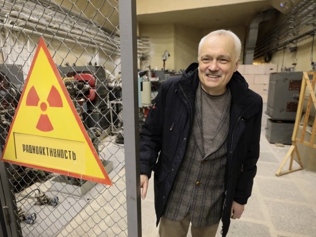
Valery Grigoryevich Yuferev – Doctor of Agricultural Sciences, Chief Researcher, Head of the Laboratory of Geoinformation Modeling and Agroforestry Landscapes Mapping of the Federal Research Center for Agroecology of the Russian Academy of Sciences – spoke about the problem of land degradation in the arid regions of the country, how the processes of desertification of farmland are monitored, and in particular, how the dynamics and vector of desertification in the European South of Russia are determined using satellite and cartographic data.
Currently, the main areas of work of scientists of the Laboratory of Geoinformation Modeling and Agroforestry Landscapes Mapping of the Federal Research Center for Agroecology of the Russian Academy of Sciences to study the state of agricultural landscapes in arid regions of the country are connected, according to Valery Yuferev, “primarily with the identification of the main patterns of changes in the state of landscapes in arid regions with changing climatic conditions and anthropogenic load. To assess the level of degradation of landscape components, the state of the corresponding territories is monitored using the results of aerospace research, spatial geoinformation modeling with a mathematical description of spatiotemporal changes, based on which a forecast of the state of arid landscapes is developed.”
For this purpose, in agroforestry research, Volgograd specialists carry out an information assessment to identify the ecological state of desertification foci or when landscapes change. Land mapping is carried out according to four levels of degradation, which is calculated from the zonal norm (since the norms will be different for the semi-desert and steppe). The main task is to determine the spatial distribution of contours with different states in the studied area. Spatial operations with encoded data are possible only with the use of specialized computer programs that provide the collection, storage, processing, analysis, and output of spatial information in the form of thematic maps, that is, geoinformation programs.
According to the researcher, the mapping of desertification (according to the UN Convention, this is land degradation of arid territories) is carried out “to determine the distribution areas of land degradation, the forms, and extent of its manifestation, as well as to assess the consequences and is necessary for visualizing and justifying the main directions and choosing ways to implement measures in general schemes and projects aimed at neutralizing desertification.”
The methodology of the study of degradation and desertification of landscapes by scientists of the Federal Research Center for Agroecology of the Russian Academy of Sciences is based on the original methods for assessing the state of landscape components, for which patents RU No. 2327107, No. 2265839 have been issued (see photo below).
As Valery Yuferev explained in detail, “geoinformation methods are of particular importance for research, providing the possibility of identifying degradation and desertification in the spatiotemporal aspect, considering natural and anthropogenic impacts. The processes of degradation and desertification are confined to the physical and geographical conditions of the territory under consideration. Changes in the state of landscape objects are caused by seasonal changes in climatic conditions, annual cycles of humidification, changes in the average annual and seasonal sum of temperatures, as well as anthropogenic impacts associated with both the use of natural resources and the transformation of the territory.”
Geoinformation assessment of the degradation level (founded on the 4-level “norm, risk, crisis, and disaster” degradation scale by B.V. Vinogradov) is based on the analysis of the image of aerial and satellite images, both actual and archival, which makes it possible to identify changes, for example, the area of open, vegetation-free surfaces, subsequent mapping of changes in the state of relief, soils and vegetation, and comparison of the maps obtained with field standards.
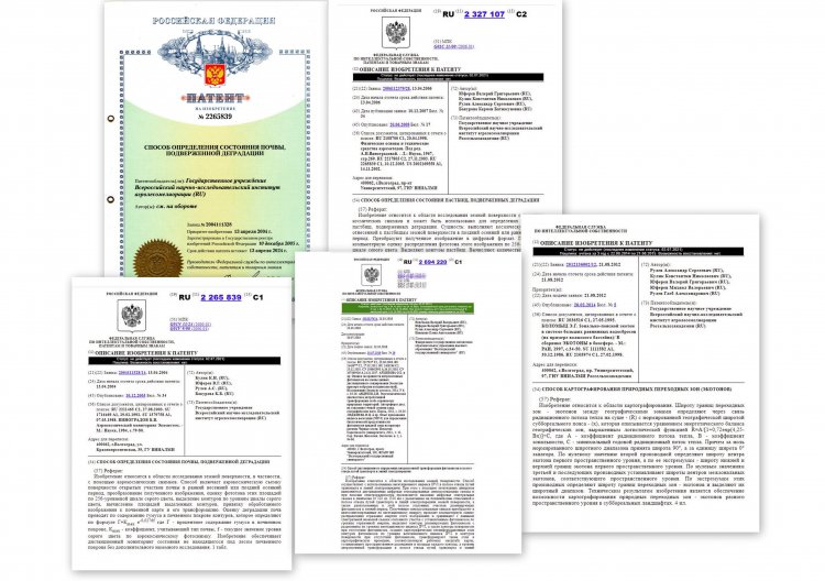
Patents obtained by scientists (including V. Yuferev) of the Federal Research Center for Agroecology of the Russian Academy of Sciences (Volgograd) for methods of assessing the state of landscape components
The accuracy of the contours is determined by the resolution of the original images (pixel size on the ground). Large-scale shooting with the help of unmanned vehicles can have a resolution of 1 cm, satellite – starting from 30 cm, current and archival images with a resolution of 10 m are freely available. The foci of desertification are large, reaching tens of thousands of hectares, so the accuracy is quite high. The location accuracy is determined by the accuracy of the geo-positioning of the images, varies slightly for different media, and is close to the resolution of the image. As a result of geostatistical processing of spatial data and their comparison with GNSS (positioning system) field data, we obtain the values of the confidence interval (spread) in spatial position and contour area.”
In this case, the mathematical description of degradation processes is based on geoinformation analysis of spatial and temporal changes of research objects. “Regression analysis of dynamic processes of landscape changes provides the development of equations for an adequate mathematical function with a certain level of confidence probability and, accordingly, the determination of approximation coefficients. Modeling of spatial changes in degraded and desolate areas is carried out using the obtained equations, while geoinformation cartographic layers are developed to reflect the forecast of the state of landscapes. The prediction of landscape degradation is based on well-known methods: spatial-temporal similarity, ecological series, etc. The forecast of degradation of complex landscape systems with spatially distributed characteristics is based on the study of spatiotemporal statistics, identifying patterns, and establishing the dynamics of changes in their components,” the researcher said.
In addition, a remote cartographic assessment of degradation processes in agricultural landscapes is being carried out, which, as Valery Yuferev clarified, is “the implementation of geoinformation technologies for the development of geoinformation cartographic layers of land degradation processes using remote sensing data of the surface. Such layers combine raster, vector, and attribute spatial data on degraded areas into a single product.”
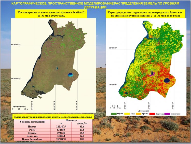
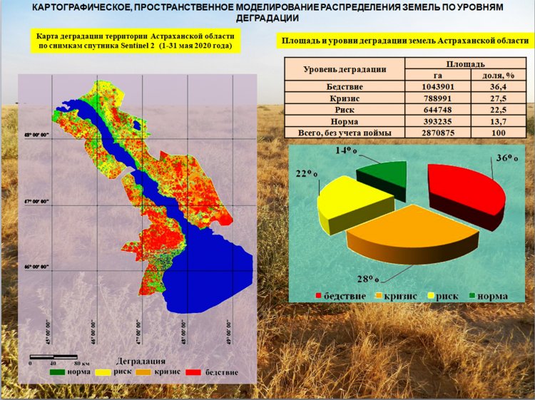
Images of the research region (above – the Volgograd Volga region and below – Astrakhan Oblast), developed based on satellite images of the Sentinel 2 satellite system (from May 1 to May 31, 2020). Images provided by V. Yuferev
Today, the Republic of Kalmykia, Astrakhan, and Volgograd Oblasts are considered major centers of natural and anthropogenic desertification of agricultural lands. What is the current degree of desertification (degradation) of agricultural land in the European part of Russia and where has the critical level been identified?
“In 2020, as a result of unfavorable hydrothermal conditions (atmospheric and soil drought), which caused low productivity of vegetation on pastures, excessive pasture loads, and the invasion of locusts, there was practically no natural vegetation left in the Northern Caspian region by autumn. In this regard, strong and steady winds of the eastern and south-eastern directions in the period from September 26 to October 2 and from October 9 to 11, reaching speeds of more than 20 m/s, led to the formation of dust storms, intensification of Aeolian processes and the transfer of sand and dust masses.
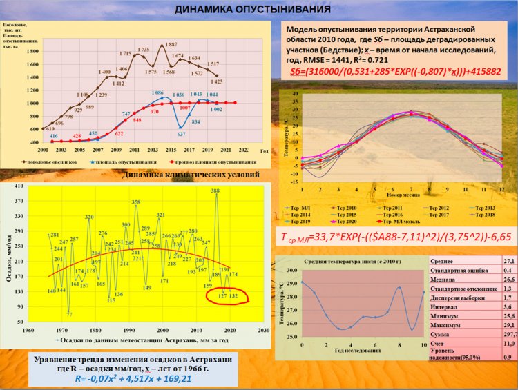
As of May 2021, on the territory of the Republic of Kalmykia with a total area of 7473100 hectares, there were 1,271 thousand hectares (9.4% of the republic’s area) at the “disaster” level (projective coverage of less than 10%), of which 870 thousand hectares were open, devoid of vegetation surfaces. And only 17% of the land area can be attributed to the “norm” level. The study of desertification foci on the territory of the Astrakhan Oblast was carried out on an area of about 3 million hectares (excluding the floodplain territory). It was established that about 820 thousand hectares of this area (28%) belong to the “disaster” level of degradation.
Analysis of the dynamics of desertification of the lands of the Astrakhan Oblast for 2002, 2007, 2010, 2014 – 2021 based on satellite images of Landsat 5, 7, 8 and Sentinel 2 (2002, 2007, 2010, 2014, 2015, 2016, 2017, 2018, 2019, 2020, 2021 years), with a normalized pixel size (100 m for all images), brightness, contrast, and color balance showed that in 2021 the areas of desertification foci decreased to 821 thousand hectares, which is explained by a sharp decrease in the number of goats and sheep according to official data for September 2021 from 1425 thousand in 2020 to 1255 thousand in 2021, which is due to the impact of dust storms on pastures and the destruction of the fodder base in September – December 2020.
In the Volgograd region in 2021, the “disaster” level was noted on the territory of 321 thousand hectares, mainly on the territory of the Pallasovsky District, which is about 12% of the territory of the Volgograd Volga region (2.7) million hectares,” Valery Yuferev shared detailed information.
As a rule, the main causes of desertification are an increase in anthropogenic load (mainly pasture) under consistently arid climatic conditions and climatic desertification, especially with an unfavorable combination of climatic factors (lack of moisture, high temperature). A negative role is also played by the landscape conditions of the young coastal plain, associated with the predominance of sandy loam soils and sands, the close occurrence of salts, low soil fertility, and irrational nature management (plowing of sands).
Trends in the modern dynamics of land degradation, according to the scientist, “are also associated with the process of phytodesertification – the reduction of useful pasture vegetation species (cereals, legumes) and their replacement with ruderal species (poisonous – harmala, poorly–eaten – camelthorn, practically non-edible – Artemisia arenaria, saltwort). The emergence of these plants displaces pasture species, reduces species abundance, causing species desertification. On the other hand, there is a consolidation of mobile dunes, which has a positive effect on the stabilization of the open surface areas.”
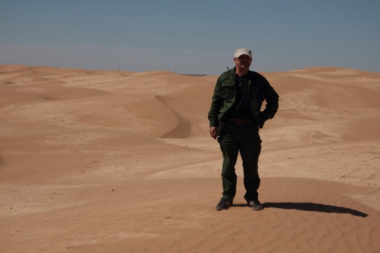
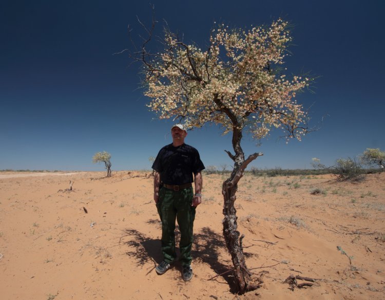
The Akim sand massif on the western outskirts of the village of Privolny is a mobile dune with an area of about 9 sq. km. This is a typical example of a desertified territory. There are salt lakes (sors) around. In summer they dry out and a crust of salt remains. Mobile sands can move in the direction of the village with strong westerly winds.
In this regard, specialists of the Federal Research Center for Agroecology of the Russian Academy of Sciences have developed a model for forecasting desertification.
Valery Yuferev explained what it is and how it works in practice: “The local model of the change in desertification is based on the logistic dependence (Gauss distribution), which describes the transition from the initial state (norm) to another state (disaster) of the research area associated with an increase in the areas of desertification foci. The model was developed for the Astrakhan Oblast for an area of about 3 million hectares, except for the azonal territory of the Volga-Akhtuba floodplain. It is a model of spatial-temporal analogy describing the change in the area of desertification foci over time according to the data of previous years. It assumes the continuity of the progress of the active factors that cause the process of changing the areas of desertification. Extreme events leading to catastrophic changes in the research area are not considered here. The result is a forecast that the area of desertification will correspond to the model, provided that the trend of changing conditions (factors) persists.”
What is the advantage of your development over existing ones? How is the regional approach taken into account?
“The advantage of the model is that it is the only operating model with an established degree of adequacy that determines the areas of desertification foci in the medium term. The forecasting base is 2002 – 2010. After 2010, the mathematical basis of the model has not changed. Since 2015, the model area of desertification foci has reached a plateau of 1 million hectares. Further, fluctuations in values relative to the plateau have been noted over the years, associated with both changes in the anthropogenic component (the number of sheep and goats) and climatic factors (annual moisture, droughts, dust storms).
The analysis of the dynamics of climatic conditions showed a tendency to decrease both the annual precipitation minima and the average precipitation for the period after 1995, which causes the probability of an increase of degraded landscapes. Considering the dynamics of maximum temperatures, we can say that the average long-term temperature of 25.6 °C is set for July. Since 2010, the average temperature has been 27.1 °C. That is, the actual increase is 1.5 °C. With a standard deviation of 1.3 °C. The standard sampling error is 0.4 °C,” the scientist pointed out.
Images of the desertification model of the research region (Astrakhan Oblast).
Valery Yuferev rightly notes that “land degradation and desertification are among the global environmental problems of mankind. Within the last century, the rapid industrial development and global warming are causing pollution of the atmosphere, soil, and reservoirs with mechanical, chemical, and radionuclide substances, which leads to aridization of territories, and eventually their degradation, disruption of the ability of the agricultural sphere to self-regulate and recover naturally. Soil degradation, i.e., deterioration of its quality because of the impact of anthropogenic and natural factors leading to a partial loss of accumulated organic substances by the soil reduces its ability to perform resource- and environment-replenishing functions. One of the manifestations of degradation is desertification. The most obvious consequences of desertification are the degradation of pasture lands and the decline in food production. As a result, there was a need for a strategic approach both to the restoration of degraded lands and to the prevention of degradation processes in the future based on a scientific approach to the sustainable use and rational consumption of natural resources.
The combination of the impact of all negative factors of irrational nature management and land use causes significant damage to arid territories of Russia and makes them unsuitable for normal farming. The most important and priority task of science and practice in the current conditions is the restoration of soil fertility, productivity and ecological stability of waste, saline, flooded and periodically flooded lands, mobile sands, the creation of environmentally sustainable, highly productive agricultural biocenoses, and productivity-optimized meliorative plantations on degraded lands, with their subsequent use in agriculture.”
What are the proposed strategic bases for soil conservation or mechanisms for managing the risks of desertification, land degradation, and droughts in the European part of Russia?
“In modern conditions, the fight against desertification and the prevention of land degradation is one of the priorities of the state policy of the Russian Federation both in the field of environmental protection and in the socio-economic field. The relevance and importance of solving the problem of desertification and land degradation are also emphasized by the active participation of our country in relevant international agreements and organizations: first of all, the United Nations Convention to Combat Desertification (UNCCD), which entered into force in 1996.
The causes of land degradation are defined for their assessment and monitoring as ordered sequences of cause-and-effect relationships, which, with a certain predisposition of a particular territory, can lead to the emergence or intensification of degradation processes.
Geoinformation analysis of desertification of arid territories has shown that in modern conditions, the stability of ecosystems is decreasing with the aridization of the climate. The meridional gradient of the total degradation index of agricultural land in the European part of the arid belt is 2 points per 100 km. The forms of desertification are determined by a complex of natural and anthropogenic factors. Among the natural factors, especially important are the ratio of average annual precipitation with annual evapotranspiration, granulometric composition of soils, terrain, and the most important anthropogenic factors include the nature and intensity of agricultural activity. Determining the state of landscapes using geoinformation technologies and aerospace data, identifying changes in desertification foci showed that the area of degraded and desolate lands increases with the growth of livestock. The role of climatic factors is increasing, which leads to an increase in the speed and amplitude of changes in desertification foci, both decreasing, with sufficient moisture, and increasing in dry years. Landscape fires have a significant impact, which leads not only to a decrease in the projective coverage but also to the depletion of the vegetation species composition, the dominance of ruderal species.
The extremely aggravated situation due to the degradation of vegetation and soil cover, the shortage of water resources, and the discomfort of human habitation prompted the Kalmyk authorities, with the support of UNEP, Russian scientists and specialists in the late 1990s to develop and begin implementing a special Republican National Action Program to Combat Desertification. It was the first strategic document of its kind in the Russian Federation. Then, within the framework of the UNEP/CIP/FRCA international project Support for Combating Desertification in the Commonwealth of Independent States (CIS), a series of Subregional National Action Programs to Combat Desertification (NAPCD) was developed for 17 regions of the Russian arid belt.
The implementation of the General Scheme to Combat Desertification of Black Lands and Kizlyar Pastures led to the fact that meliorative agroforestry works were carried out on an area of over 7 thousand sq km, more than 4 thousand sq km of mobile sands were anchored and more than 2.5 thousand sq km of pastures were restored,” added the Volgograd researcher.
In addition, the assessment of the productivity of forage lands and the identification of ways to increase their forage capacity, as noted by Valery Yuferev, “was carried out by many scientists who found that an integral element of the strategy for the sustainable development of pasture livestock is the ecological restoration of the degraded part of natural pasture ecosystems and the use of a risk management system for desertification, land degradation and the impact of droughts. Part of such measures is the Phyto- and forest reclamation of semidesert-steppe communities (anchoring sands with grasses, subshrubs, and woody plants, improving grasslands by sowing grasses, creating protective forest plantations, etc.), which ensures the restoration of agro-resource potential and improvement of the functioning conditions of degraded lands using adapted, highly productive herbaceous and woody vegetation. In protected areas, the hydrothermal regime is significantly improved, surface runoff is reduced, soil formation processes are optimized, rivers and reservoirs become cleaner and fuller, flora and fauna become richer and more diverse.
Phytomeliorated lands are effectively used, stably produce, become zootechnically comfortable and provide an increase in the number of animals: the preservation of sheep increases by 7%, weight gain by 13%, shearing by 10-40%. The costs of restoring desolate pastures by phytomelioration pay off in 4-5 years. In arid semi-desert and steppe areas, phytomeliorative measures are more effective the larger the territory they cover.”
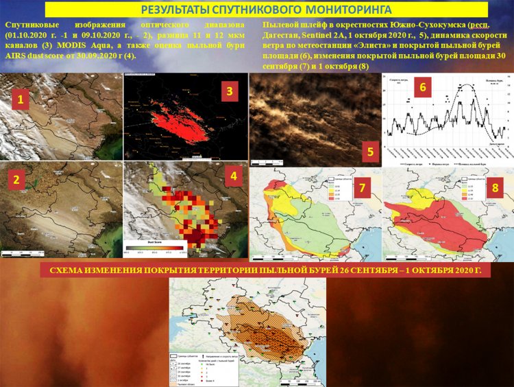
Results of satellite monitoring of dust storms based on Sentinel 2 satellite data (as of October 1, 2020) in the vicinity of Yuzhno-Sukhokumsk (Republic of Dagestan).
What is the current state of the forest strips and how do they perform the protection function?
“In the zone of semi-deserts and deserts in the south of the European part of Russia, it is possible to talk about forest plantations in the form of strips only with proper organization of care for them. Arboreal species – trees are applicable here in a limited way if there are appropriate conditions. Probably, to protect pastures it is necessary to discuss the creation of shrub and semi-shrub plantings that can exist without a care in such conditions (Tamarix, juzgun, etc.). Existing (or no longer existing) forest strips of tree species (in the form of trees) in semi-desert conditions (on light chestnut soils) cannot function without care. They will not grow on brown and sandy soils in the absence of root-accessible moisture. Upon termination of the use (processing) of fields, the strips degrade and disintegrate very quickly, in some places even individual trees do not remain. If we consider the Caspian lowland, then, for example, the Chapaevsk-Vladimirovka state forest strip has been preserved fragmentarily only in the Staropoltavsky District,” Valery Yuferev said.
A sandy massif near the village of Smushkovo (Kalmykia), anchored with a subshrub (leafless Juzgun). V. Yuferev near the Juzgun bush.
Where else can we apply the results of monitoring arid ecosystems obtained by you during the geoinformation and remote cartographic assessment?
“We are developing scientific foundations, methods, and technologies for geoinformation analysis of the degradation of landscapes of arid territories, which makes it possible to use them to perform engineering work to assess the condition of the lands of the federal subjects of Russia, based on which it is possible to make management decisions about the mode of economic use of such objects, their rehabilitation, changes in the mode of use, etc. to ensure the restoration of their functions and prevent further degradation and desertification of lands,” the employee of the Federal Research Center for Agroecology of the Russian Academy of Sciences assured.
Thus, the successful search for degraded sites and a comprehensive analysis of the state of agricultural landscapes in regions prone to desertification (including cartography data, geoinformation assessment, information from satellites, and field expeditions), conducted by Volgograd scientists, makes a significant contribution to the development of a unified strategy for biodiversity conservation and prevention of the causes of change and further development of the forming components of arid ecosystems.
Photo by V. Yuferev, S. S. Shinkarenko


