


When people speak about climate change, they pay more attention to carbon dioxide. However, it is water vapor that is the most influential greenhouse gas in the atmosphere. The gaseous form of H2O absorbs considerably more infrared energy emitted from the Earth’s surface than other greenhouse gases and traps more heat. Some scientists believe that water vapor plays a significant role in amplifying devastating storms and accelerates climate change. Is that true? Daria Gushchina, Professor of the Department of Meteorology and Climatology at the Faculty of Geography of Lomonosov Moscow State University (MSU) and the Russian Academy of Sciences (RAS), answers these questions.
Daria Yuryevna Gushchina — Professor of the Department of Meteorology and Climatology at the MSU Faculty of Geography, RAS Professor.
— In 2021, while reeling from the pandemic, the entire world faced abnormal weather conditions such as devastating floods and strong heat. Is this what climatologists warned us about when they said climate change would be accompanied by more and more anomalies?
— We observed anomalies not only in 2021. In fact, abnormal weather conditions are registered every year. I often point out in my interviews and lectures that we should clearly define what we mean by abnormal because, in science, climate normals are average temperatures. For example, we took the 15 March values of temperatures for a period of 30 years, added them up, and divided them by 30 to get the average temperature. This average temperature could differ from the actual temperature registered on March 15 over these 30 years. From a mathematical standpoint, any deviation from the average value is a temperature anomaly by default.
Meanwhile, in real life, our approach to interpreting this or that phenomenon is often subjective, that’s why an anomaly is commonly associated with a significant deviation from the norm. But then again, everything depends on the region. All temperature fluctuations are mitigated by the ocean or another large body of water in areas with an oceanic climate. For this reason, the magnitude of deviations in coastal areas is lower than in intercontinental territories.
Some areas are characterized by more stable atmospheric circulation patterns. For example, the famous trade winds blow all year round in the tropics. We remember these winds from our geography classes. They should be the first meteorological phenomenon that was discovered and described by seafarers as early as the 15th-16th centuries. All great geographical discoveries are based on knowledge about the strength of the trade winds. Why do surfers prefer areas with the trade winds? This is because they can catch the wind and waves whenever they go surfing.
In contrast to this, there are areas with unstable weather conditions that are most often associated with the circulation of southern and northern air flows that bring cold air, then warm air. That’s why weather conditions are highly changeable on the east coast of North America. Northern winds reach Florida, and it can snow there. Southern winds reach Canada, where it can rain even in winter, and the snowpack melts.
Therefore, there are different manifestations of anomalies. Climatologists prefer to talk about extreme weather events, the criteria for which are defined quite clearly. There are different approaches to understanding extremity in different countries, but threshold values are universal.
As climate warms, the number and frequency of extreme events increases. For a long time, this used to be a matter of heated debate among scientists. Some referred to human subjectivity. I think you will agree that people perceive climate change as far more extreme now than they used to in the past. After all, there was not much focus placed on climate in the media in the middle of the last century, and the global information exchange was far less large-scale.
People used to hear about extreme weather events several times a year. Today, they are informed about it every day. There is a curious trend to be observed in the informational field now: they discuss weather when there is nothing else to discuss or when they need to shift the focus from a truly important matter. Therefore, we cannot disregard social, economic, and political factors that are behind our interest in extreme climate events.
Along with this, objective scientific findings do demonstrate that the frequency of extreme events increases due to climate change. Again, everything depends on the region. We already had snowless winters in the Moscow region in the past, we just paid less attention to this fact. In my opinion, people have become more sensitive to extreme events and news with the development of civilization. We have become more sensitive to everything. I am no psychologist, and I do not pretend my conclusions are scientifically sound. It’s just how I feel about it.
— When people talk about climate change, they mention greenhouse gases. What effect do they have on climate?
— Let’s start with what the greenhouse effect is. We find a lot of false information on it, especially in popular sources. What is even more alarming is that incorrect facts are found in school textbooks that tell us about the primary threats to humanity due to the greenhouse effect, acid rains, and ozone holes. We will not discuss acid rains or ozone holes now — they are separate topics. However, if there was no greenhouse effect, the average temperature on Earth would be 18° C below zero. Life could probably arise in such conditions, but we do not know what it would be. Fortunately, Earth’s average temperature is 15º C above zero. It is exactly the greenhouse effect responsible for it.
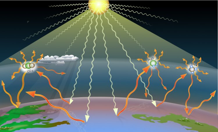
The greenhouse effect
A greenhouse is useful for farmers and gardeners. Similarly, the greenhouse formed by our atmosphere protects all life on Earth. Think of the use of greenhouses in vegetable gardens. A greenhouse is transparent so sunlight shines through and heats the soil. The earth absorbs heat and emits radiation: in contrast to the shortwave radiation produced by the Sun, this one is longwave. The wavelengths are different, as the temperature of the Earth is significantly lower than that of the Sun. The greenhouse gases are not transparent to longwave radiation meaning that the heat stays inside the greenhouse.
As to the atmosphere, it is atmospheric air that plays the role of a protective film or glass cover here. It is transparent to shortwave radiation coming from the Sun and not transparent to longwave radiation emitted by the Earth.
Atmospheric air contains many gases. The main ones are nitrogen (78%) and oxygen (21%). However, these gases are not involved in the greenhouse effect. Those involved are the so-called greenhouse gases. The levels of greenhouse gases in air are very low, that is, less than 1%. Everyone is familiar with carbon dioxide (CO2), methane (CH4), nitrogen dioxide (NO2), and others. Meanwhile, the most important greenhouse which is often overlooked is water vapor. For some reason, even students do not associate water vapor with gas.
Water vapor is a unique atmospheric constituent as it is only the water molecule (H2O) that can exist in three phases: gas (water vapor), liquid, and ice. These are the phase transitions of the H2O molecule that underpin many interactions and processes in the climate system.
— What are the reasons?
— The concentration of water vapor in the atmospheric air changes constantly and within very wide limits. In addition, it strongly depends on air temperature, land-water distribution, and, of course, incoming solar energy, that is, the amount of solar radiation needed for evaporation. Water vapor is a very powerful greenhouse gas, indeed.
— Then why do people mainly focus on carbon dioxide?
— The concentration of water vapor varies considerably almost every minute, but these are fluctuations rather than a trend. Throughout the last hundred years, the average concentration of water vapor has changed insignificantly across the Earth, while the change in the levels of carbon dioxide has been considerable. For example, the concentration of carbon dioxide in the atmosphere was 280 parts per million (ppm) in the pre-industrial period. Today it is 416.
These are human activities that have doubled the concentration of CO2.
But there are also purely physical factors that are discussed less widely. Water vapor absorbs almost all wavelengths emitted by the Earth except those ranging within the interval of 8-12 microns, that is, the so-called atmospheric windows. In this interval, water vapor releases radiation emitted from the Earth into space. However, at temperatures registered on Earth today, it is this interval through which most radio waves pass. The absorption band of CO2 is likewise centered within this interval. Thus, despite its very low levels in the atmosphere (less than 1%), there is a variety of factors, due to which, the radiative forcing performed by carbon dioxide, that is, its contribution to blocking Earth’s radiation, is very significant. From the standpoint of average values though, the contribution of water vapor to the greenhouse effect is far greater.
— It is believed that water vapor plays a huge role in amplifying disastrous storms and hurricanes and accelerating climate change. Is it true?
— Everything is far more complicated. Let’s consider the details. First of all, when we speak about hurricanes as a weather phenomenon, it is more correct to call them tropical cyclones. A cyclone is only called a hurricane when its speed exceeds 33 m/s. Besides, the term is only relevant to the Atlantic Ocean. Disastrous tropical cyclones are called typhoons if they are formed in the northwest part of the Pacific Ocean and willy-willies if formed off the coast of Australia. Here, we mean a tropical cyclone that has progressed into the third stage, and the wind speed of which has exceeded the threshold value.
A combination of giant pressure gradients that cause stormwinds and heavy clouds that bring catastrophic rainfall to the mainland emerges due to the condensation of moisture that generates in the process of evaporation from the warm surface of the ocean. For this to occur, sea surface temperature should be above 27º C. That’s why tropical cyclones do not form in the tropics of the eastern Atlantic Ocean or on the western coast of South America washed by the cold Peru Current.
A large amount of water vapor rises with the air after evaporation. Condensation releases a huge amount of energy known as the latent heat of condensation. This heat is a source of energy for tropical cyclones.
It is important to understand that tropical cyclones are a purely regional phenomenon. A cyclone is formed in a specific zone of the ocean under certain atmospheric circulation conditions.
Therefore, it is wrong to say that a global increase in the concentration of water vapor will amplify a particular hurricane. However, as a result of climate change and an increase in global sea surface temperature, there will be more zones in the ocean with temperatures above 27º C. Therefore, tropical cyclones will be able to form at higher latitudes and will be distributed more widely.
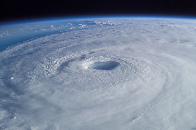
Hurricane Isabel in 2003 as seen from the International Space Station. The eye, eyewall, and surrounding rainbands, characteristics of tropical cyclones in the narrow sense, are clearly visible in this view from space
— Will they become more devastating?
— It is hard to say at the moment. Some research studies show that certain changes in the ocean-atmosphere system associated with the natural Atlantic Interdecadal Oscillation can influence the intensity of cyclones: that is, they can amplify cyclones that progress from the third to the fifth stage. At the same time, the total number of tropical cyclones varies insignificantly.
As to the relationship between water vapor and climate warming, everything is quite complicated and ambiguous here too. Temperature rise leads to higher vapor pressure. This is a measure of how much water vapor the air can absorb. Depending on the temperature, air works like a sponge and every sponge has its limits. In nature, the absorbency rate depends on air temperature rather than air composition: the warmer air is, the more water vapor it can absorb. This correlation increases exponentially. If air temperature rises by 3 degrees, air can absorb 20% more water vapor. Consequently, the absolute concentration of water vapor on the Earth will increase by 20% if the temperature rises by 3 degrees.
Relative humidity is another important indicator. It is distributed very unevenly, and it can be absolutely different at the same temperature. For example, the climate in Crimea or the Volga region is quite dry, while the Caucasian coast in Sochi has humid subtropical climate. Temperature levels in these areas are identical, about 25º C above zero. Anyone who has ever dried towels and swimwear outside in these two regions knows that clothes are dry faster in Crimea and the Volga region than in Sochi at the same temperature. The point is that in the former case, there is very little water vapor in the air. In Sochi, air, on the contrary, contains a lot of water vapor. The difference between the actual amount of water vapor in the air and the amount it can absorb is called relative humidity. When air contains the maximum amount of water vapor it can hold, its relative humidity is 100%. For example, all washing machines in South America, in Peru or Ecuador, are washer-dryers because you cannot dry anything outside.
This is why actual changes in the concentration of water vapor are more important than an increase in the maximum possible concentration of water vapor caused by temperature rise. If global ocean surface temperatures increase, the evaporation rate will be higher, which means that more water vapor will enter the atmosphere.
Recent scientific findings show that the concentration of water vapor increases, and so the greenhouse effect intensifies. However, it is necessary to consider multiple regional features associated with the land-sea distribution, distribution of relative humidity, and sources of evaporation as well as the effect of phase transitions, clouds, and precipitation.
— You have mentioned that the latitudes of tropical cyclones can increase with time. In what areas cyclones will appear for the first time?
— In fact, cyclones will never emerge in the areas where they have never been present before. We only mean some small areas here: for example, if cyclones form within 20 degrees north and south of the equator today, they will form within 22 degrees in the future.
However, there are interesting aspects to the interaction between tropical and extratropical processes. A tropical cyclone causes hurricanes, precipitation, floods on the coast, as well as storms in oceans. As it travels deeper into the continent, it gradually disappears when moving across land. A similar situation takes place when it enters high latitudes where the colder water surface is found. However, temperate latitudes have their own cyclones that form on atmospheric fronts. They are less intense and form differently. When approaching these latitudes, a tropical cyclone can merge with a temperate cyclone. Therefore, if a tropical cyclone moves above 20 degrees, the likelihood of tropical cyclones forming along the polar front increases.
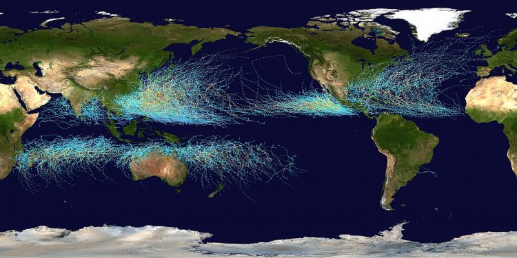
This map shows the tracks of all Tropical cyclones which formed worldwide from 1985 to 2005. The points show the locations of the storms at six-hourly intervals and use the color scheme shown to the right from the Saffir-Simpson Hurricane Scale. However, remnants of the storms are not shown as triangles
— Can we observe this in Europe?
— No. Tropical cyclones move to the eastern coasts of the continents as they merge with trade winds traveling from the east to the west.
As for Europe, it has its own phenomena. It has been recently discovered that tropical-like cyclones form in the Mediterranean Sea. They are called “medicanes.” These are small yet very unpleasant cyclones that cause intense precipitation. If a tropical cyclone appeared in Europe, its consequences would be as dangerous as, say, in the Caribbean. European medicanes with their precipitation are dangerous, too.
I should mention the so-called feedback processes in the climate system. They involve a process and a response to it. This response can either strengthen the process, which is positive feedback, or weaken it, which is negative feedback.
The best-known positive feedback in terms of climate change is concerned with surface reflectance (albedo). Simply stated, as the temperature rises, ice and snow melt faster, but they intensively reflect incoming radiation. This increases the area of open soil that absorbs radiation more efficiently. The heated earth heats the air and the temperature increases even further.
Source: NASA Climate Change
However, there is also negative feedback. One of the causes of climate warming is an increase in CO2 concentration. As we know, one of the main carbon dioxide drains is the global ocean. As the climate warms, the level of the global ocean rises, and its area increases. Hypothetically, the amount of absorbed CO2 must increase, but we do not have many results confirming this now. Besides, even the most up-to-date climate models only deal with a limited number of types of climate feedback processes.
To continue our conversation about water vapor, I will note that today there are some consistent theories that link the change in water vapor concentration with climate warming, but, unfortunately, some of them are not supported by observational data. Besides, if we take into account negative feedback too, it is impossible to tell for sure if the greenhouse effect increases when water vapor concentration grows or whether there might be another scenario, where the temperature decreases. Indeed, water vapor enters the surface air layer during evaporation. Then the air can rise while cooling. The amount of water vapor that can be contained in the air depends on the temperature. If the latter decreases, the water vapor that was previously contained in the atmosphere becomes redundant. It turns into drops of moisture to form clouds. Such a cloud gradually grows, the drops become heavier, and at some point, precipitation occurs. The coalescence of drops is not enough to produce precipitation: this will not be precipitation but drizzle at best. To produce rain or snow, there have to be ice crystals in the air. Thus, there must be two phases of water: liquid and solid.
The idea of negative feedback suggests that air gets dry as a result of precipitation. Thus, after precipitation, air under the clouds becomes drier, and all moisture returns to the Earth, which means that there remains less water vapor in the air. Warming, increased evaporation, and a large amount of water vapor entering the atmosphere form heavier clouds leading to heavier precipitation. In this case, the air gets dry so that it contains a smaller amount of water vapor. In the meantime, it is the latter that blocks the Earth’s radiation. Thus, the Earth’s surface loses more heat, which means that its temperature should decrease. This sounds logical, but so far, we do not have the observational data or calculations that would support the idea that this effect prevails over or fully compensates for the increase in evaporation and water vapor concentration as a result of the rise in sea level and air temperature.
— Modern climate studies are based on satellite data and computer calculations. Do you cooperate with MSU departments that perform such calculations?
— Of course. For example, Deputy Director of the Research Computing Center of MSU Victor Stepanenko is our graduate. This year, he received the Shuvalov award.
Our employees, students, and postgraduate students make calculations using the Lomonosov-2 supercomputer. The domestic climate model created at the Marchuk Institute of Numerical Mathematics of RAS is also actively developing. The Institute cooperates with colleagues from the Research Computing Center and makes calculations via the MSU supercomputer. Therefore, today we are working within a consortium of MSU, our department, the Research Computing Center, the Institute of Numerical Mathematics of RAS, Hydrometcenter, and other scientific, educational, and computing centers in Russia.
Our work is focused on the development of a domestic climate model included in an international model comparison project. They allocate funding every year for these purposes, while our staff and postgraduate students are engaged in this process.
— If we compare the period when you started to study the climate and the present time, how much has the equipment changed?
— It has drastically changed. For example, my peer wrote her thesis on satellite data in the 1990s. Thus, the error in temperature reprofiling at different heights of the troposphere based on satellite data was about 7 degrees at that time, that is, the temperature could be either 10 or 17 degrees. Today, this error is less than one degree, which is huge progress.
There are a lot of new electrical and ultrasonic equipment units, automatic meteorological observation stations, and so on. Climatologists and meteorologists take measurements using drones, although the barometer and traditional mercury thermometer are still present in their equipment kit.
— What is your focus today?
— I continue studying my favorite El Niño that we discussed last time. At present, I am examining the response to El Niño that occurs in the temperate latitudes and even in high latitudes. Together with my student Maria Kolennikova, we studied circulation response in the troposphere and stratosphere to various types of El Niño, to the forcing or signal that comes from tropical latitudes. We compared the northern and southern hemispheres and discovered that the response was different. This means the stratosphere and the troposphere react differently to the two types of El Niño in the two hemispheres.
Besides, we have received a grant to study extreme weather events and their relationship with fluctuations in greenhouse gas streams. In the frame of the grant, our equipment base will be extended, too. Together with Professor Alexander Olchev, an employee of the Department of Climatology and Meteorology, we decided to determine what kind of a response extreme weather events may cause in greenhouse gas streams. We have already started this work and I hope that we will get interesting results.
— What can a single person do to help solve the climate change problem?
— Sort waste, turn off the lights and avoid wasting water. These are mere trifles in our daily routine, but they do make a difference.


